DJI Matrice 350 RTK and Zenmuse H30: Professional Drone Photography Explained
For many photographers, a drone means a compact aircraft carrying a relatively small camera. But there is another side to aerial imaging: large professional UAVs designed to carry sophisticated camera and sensor systems for inspection, surveying, public safety and other specialist applications.
The DJI Matrice 350 RTK sits firmly in this category.
Combined with the Zenmuse H30 Series payload, it becomes a very different proposition from the lightweight drones commonly used by photographers. This is equipment designed for organisations and professionals who need to see, measure and record information from the air.
The system demonstrates just how far drone imaging has developed – from taking an unusual photograph from above to providing detailed visual and thermal information from hundreds or even thousands of metres away.
What is the DJI Matrice 350 RTK?
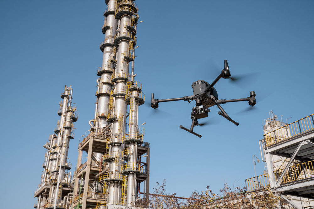
The Matrice 350 RTK is a large enterprise UAV designed to carry interchangeable payloads.
It is considerably larger and heavier than consumer-focused DJI aircraft. DJI specifies a maximum take-off weight of 9.2kg and a maximum payload capacity of 960g for a single gimbal damper. It has a quoted maximum flight time of 55 minutes under controlled test conditions without a payload.
The aircraft also incorporates RTK positioning technology, allowing highly accurate positioning when used with the appropriate RTK setup.
That accuracy is important in professional applications where the operator isn’t simply trying to compose an attractive photograph but needs to know precisely where the aircraft and sensor are located.
Why use such a large drone?
The obvious question is why anyone would need an aircraft weighing several kilograms when small camera drones are available.
The answer is payload.
A lightweight drone has to compromise between size, weight, battery life and the camera it can carry. A larger professional UAV can carry much more sophisticated equipment.
The Matrice 350 RTK supports a range of DJI gimbals and payloads, including the Zenmuse H30 and H30T, as well as systems designed for mapping, surveying and other specialist applications.
This turns the drone into a flying platform rather than simply a flying camera.
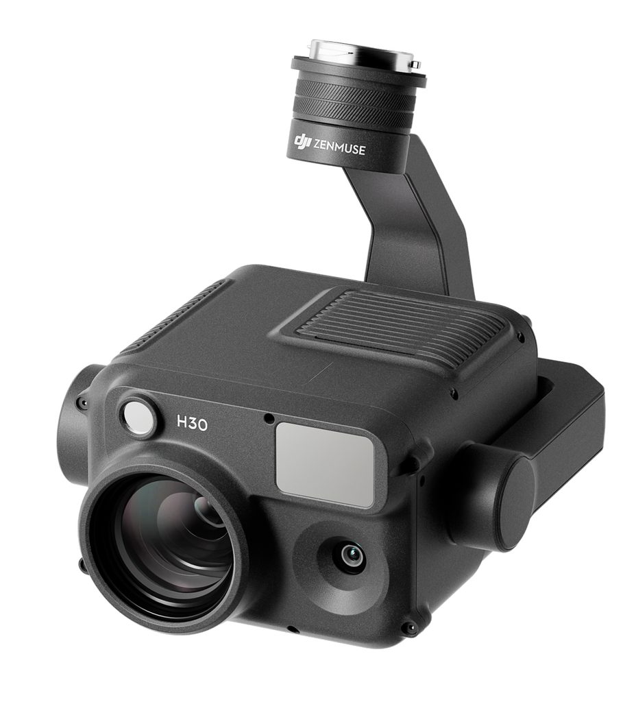
The Zenmuse H30 Series
The Zenmuse H30 is a multi-sensor payload designed for situations where seeing clearly from a distance is critical.
Its capabilities include a wide-angle camera, high-resolution zoom camera, laser rangefinder and night-vision assistance. The H30T additionally incorporates a thermal imaging camera.
This combination makes the system useful for applications such as:
- infrastructure inspection
- power and utility inspections
- search and rescue
- public safety
- firefighting
- forestry
- surveying and monitoring
- industrial inspection
For a conventional photographer, some of these applications may seem a long way from photography. But fundamentally they rely on the same principle: capturing useful visual information from a position that would otherwise be difficult or dangerous to reach.
A 40MP camera with a huge zoom range
The H30’s zoom camera uses a 40MP 1/1.8-inch CMOS sensor.
Its optical system provides up to 34× optical zoom, with up to 400× digital zoom available through the system’s hybrid zoom capabilities. DJI specifies an equivalent focal-length range of approximately 33.4mm to 809.3mm for the zoom camera.
That is an enormous range compared with a conventional interchangeable-lens camera.
The real benefit isn’t simply magnification.
Being able to examine a distant object without moving a large UAV closer can be extremely valuable when the aircraft needs to maintain a safe operating position.
For example, an inspector may need to examine a structure that is difficult, dangerous or impossible to approach directly.
The camera allows the operator to remain at a suitable distance while examining the subject in considerably greater detail.
The wide-angle camera
Alongside the zoom camera is a 48MP wide-angle camera using a 1/1.3-inch CMOS sensor.
It has a 24mm-equivalent focal length and a 82.1° diagonal field of view.
This provides the broader context around the subject.
For inspection work, that can be just as important as the highly magnified view.
A detailed close-up might show a potential defect, while the wide-angle camera establishes exactly where that defect is located on the larger structure.
In other words, the two cameras complement each other.
Thermal imaging with the H30T
The H30T adds a thermal imaging camera to the visible-light system.
Its uncooled VOx microbolometer provides a 1280 × 1024 thermal image, with a 24mm focal length and 32× digital zoom. DJI specifies temperature measurement ranges extending from below freezing to as high as 1,600°C in the appropriate configuration.
Thermal imaging opens up applications that conventional photography simply cannot perform.
Heat differences can reveal information that isn’t visible to the human eye, making thermal drones particularly valuable for certain inspection, emergency response and industrial applications.
This is where an enterprise UAV starts to become less about photography and more about remote sensing.
Seeing in difficult conditions
The H30 Series is designed to work in considerably more demanding situations than a typical photographic drone.
The system includes dedicated night-scene capabilities, while the H30T combines visible and thermal imaging. DJI also specifies an NIR auxiliary light for the system.
This matters for applications where waiting for perfect daylight isn’t an option.
Search and rescue, infrastructure inspection and emergency response can all require information immediately.
A laser rangefinder adds another dimension
The H30 Series also incorporates a laser rangefinder.
DJI specifies a range of up to 3,000 metres.
This means the payload isn’t simply recording pictures.
It can help operators determine the position and distance of a target, providing additional information that can be used alongside the camera imagery.
That combination of imaging, measurement and positioning is one of the biggest differences between an enterprise payload and a conventional drone camera.
How this differs from a photographic drone
A photographer buying a drone generally thinks about:
- image quality
- focal length
- dynamic range
- RAW files
- stability
- battery life
- portability
An enterprise drone operator may have a very different checklist.
They may be more concerned with:
- payload capability
- positioning accuracy
- range
- weather resistance
- thermal imaging
- measurement
- repeatable flight paths
- operational reliability
- data security
- regulatory compliance
The camera is therefore only one part of the system.
The aircraft, payload, controller, software and operator all form a single working platform.
Repeatable aerial inspections
One of the most useful characteristics of a professional UAV system is the ability to perform repeatable operations.
A photographer might make a flight once to capture a particular viewpoint.
An inspection operator may need to return repeatedly and capture the same structure from comparable positions.
Accurate positioning and planned flight paths can make it much easier to compare images and measurements over time.
That could be useful for monitoring construction progress, infrastructure deterioration or changes to a site.
Built for demanding environments
The Matrice 350 RTK is designed as an enterprise platform rather than a consumer drone.
DJI gives the aircraft an IP55 rating and specifies an operating temperature range of -20°C to 50°C.
The H30 Series is also rated IP54 under controlled laboratory conditions.
These specifications don’t mean the system can simply be flown regardless of conditions, but they illustrate the intended market.
This is equipment designed to operate in environments where a lightweight consumer drone may not be appropriate.
How much does a system like this cost?
This is not an entry-level photographic drone.
The original assessment put the combined aircraft and camera system at around £19,000, although pricing varies according to the aircraft, payload, controller, batteries, configuration and supplier.
That price immediately limits the market.
But the correct comparison isn’t necessarily with a £1,000 camera drone.
For an organisation using the aircraft for inspections, infrastructure work, emergency response or other commercial operations, the relevant question is whether the system can perform a job more safely, efficiently or economically than conventional methods.
A camera that can inspect something from hundreds of metres away may save significant time compared with physically accessing the same structure.
Professional drone work requires professional preparation
Buying an enterprise drone does not automatically make someone qualified to operate it commercially.
UK drone regulations have changed since this article was originally published, including changes introduced on 1 January 2026. The requirements depend on the aircraft, its class, the type of operation and where and how it is being flown.
Organisations operating drones need to consider the appropriate CAA registration, pilot competency, operational requirements and insurance. More complex operations may require a CAA Operational Authorisation.
For that reason, anyone considering an enterprise UAV for professional work should check the current CAA requirements before operating it.
The rules are not simply a box-ticking exercise. A large drone carrying expensive equipment can create significant risks if it is operated incorrectly.
Who needs a drone like this?
For most photographers, the answer is probably not you.
A large enterprise UAV becomes relevant when the job requires capabilities that a compact camera drone cannot provide.
It could make sense for:
Infrastructure inspectors
Where detailed examination of structures can be carried out without putting people in difficult or dangerous positions.
Utilities and energy companies
For examining assets such as power infrastructure and other installations.
Search and rescue organisations
Where the ability to cover large areas and see clearly in difficult conditions can provide valuable information.
Surveying and mapping professionals
Where accurate positioning and specialist payloads are more important than conventional photographic equipment.
Industrial operators
Where thermal and visual information can help identify potential problems.
Specialist aerial imaging companies
Where the cost of the equipment can be justified by regular commercial work.
The future of drone imaging
The interesting thing about systems such as the Matrice 350 RTK and Zenmuse H30 is that they demonstrate how the definition of a camera drone is changing.
The aircraft is no longer simply transporting a camera to an unusual viewpoint.
It can carry multiple imaging systems, thermal sensors, rangefinders and positioning technology. It can collect information that a person on the ground might not be able to obtain safely or efficiently.
For photographers, there is still plenty to learn from this development.
The fundamental principle remains the same as with any camera:
Get the right sensor into the right position and you can capture information that would otherwise be impossible to see.
The difference is that, with enterprise UAVs, the goal may no longer be a beautiful photograph.
It might be finding a fault, locating a person, measuring a structure or identifying a temperature difference.
Photography is only the beginning.
About the original test
This article has been substantially rewritten and updated from a Professional Imagemaker feature examining the DJI Matrice 350 RTK and Zenmuse H30 Series, with technical contribution from drone specialist and architectural photographer Paul McMullin.
Drone specifications, pricing and UK regulations can change. Always check the manufacturer’s current specifications and the latest Civil Aviation Authority guidance before purchasing or operating an aircraft.